AN INTRODUCTION TO THE DRAFT KL CITY PLAN 2020
A Summary of the Draft KL City Plan 2020 as prepared by Pusat Khidmat Lembah Pantai
What is the Draft Kuala Lumpur City Plan 2020 (DKLCP 2020)?
* Prepared under Section 13 of the Federal Territory (Planning) Act 1982, the Plan is a primary planning and development strategy framework and development control document for the City of Kuala Lumpur.
* The Plan provides guidance on use of land, its intensity of use as well as other physical and infrastructure development.
* The Plan has been prepared with the vision of KL as a sustainable city of a world class standing, where KL strikes a balance between physical, economic, social and environmental development.
* Preparation of the Plan underwent rigorous public participation process ranging from focus group discussion, stakeholders interview and engagement as well and public workshops and seminars.
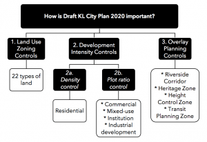
1. LAND USE ZONING CONTROL
What is land use zoning?
The designation of parcels of lands for different uses.
Why do we need land use zoning?
To regulate land use, prevent land use conflict and allow growth to occur in a sustainable manner.
How does land use zoning play a role in the KL City Plan?
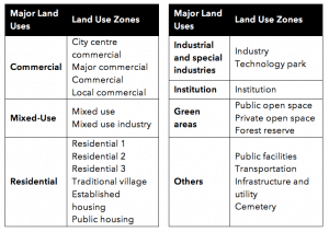
In the Plan, KL is divided into 269 zones, all of which have been designated with specific Land Use Zones. There are 7 Major Land Uses, with 22 types of Land Use Zones in KL. Any future development must conform to the zone assigned; any applications for planning permission must comply with the designated uses and activities.
2. DEVELOPMENT INTENSITY PLANNING CONTROL
The need to control the development intensity of urban activities within KL is essential in attaining a sustainable built environment for the City. As such, the Plan stipulates that development intensity in KL will be controlled in two forms:
a. Density control for residential development; and,
b. Plot ratio control for commercial, mixed-use, institution and industrial developments.
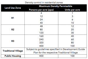
2a. DENSITY
What is density?
Number of persons to a land area.
Why does density need to be controlled?
To assist in population distribution, the planning for social amenities as well as infrastructure and utilities.
How does density play a role in the KL City Plan?
The Plan determines the maximum permissible density for lands zoned as residential.
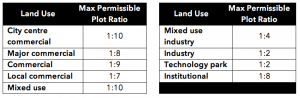
2b. PLOT RATIO
What is plot ratio?
Ratio between the total floor area of a building and the area of a building plot.
Why do plot ratios need to be controlled?
To manage sustainable development intensity that would prevent adverse effects of over-development; and, to ensure critical mass that can support the urban services such as public transportation, urban amenities.
How does plot ratio play a role in the KL City Plan?
The Plan fixes the total permissible built up area of a building within a limited plot of land for land zoned as commercial, mixed use, industrial and institutional.
3. OVERLAY PLANNING CONTROL
What are overlay planning controls?
Additional requirements and control imposed, on top of the underlying land use zoning and intensity control provisions.
Why are overlay planning controls necessary?
To ensure adequate protection for the environment and new development that are sensitive to their surrounding heritage buildings.
How do overlay planning controls play a role in the KL City Plan?
The plan lists 4 aspects which require special attention for any development.